Sunday, August 5, 2012

Anniversary Hike: Sentinel Dome

My husband stayed home and took care of our son while I hiked Half Dome last year.  Truth be told, Half Dome was my dream, not his.  Duane's dream was to have our family hike to the summit of Sentinel Dome and find the Half Dome webcam located at Sentinel Dome.  Since I had a week off this past week, we decided to seize the day!
On the Friday prior, I took the kiddo to REI to buy him a proper pair of hiking boots.  I didn't want him walking on bare granite with his Converse deck toppers.  He tried on two pairs of boots, made the entire process a struggle, and at last, he settled on a pair of Vasque hiking boots.
Getting hotel reservations at the last minute for any of the hotels near Yosemite is difficult at best.  Oakhurst and El Portal were fully booked.  We had no desire to sleep on cots in Curry Village, both because it didn't sound appealing but also because our hike began near the end of Glacier Point Road, a full hour and a half drive from the valley floor.  We finally found a room at the Chukchansi Gold Resort and Casino in Coarsegold for Saturday night.  Not much further out than Oakhurst.  Even better we had gift certificates for a free buffett dinner for two and $75 off one night at the hotel.
That turned out to be the most disappointing thing about our trip.  The gift certificate had been donated to our son's school and raffled off at the school gala last April.  The only problem was that the gift certificate expired in February, i.e., before the school gala had ever happened and before the gift certificates had been raffled off.  Although I tried to make contact with the representative at Chukchansi who donated the gift certificates, she never even returned my call.  The hotel refused to honor the gift certificates even though I explained the situation.  We paid our bill without complaint, but I nevertheless came away with a poor opinion of Chukchansi.  It seemed to me to be a very cheap thing to do.  I wonder if they took that as a charitable deduction on their tax return? 
Sentinel Dome
Nevertheless, we had a nice evening.  We had a dinner of salad at the buffet, swam in the indoor/outdoor pool, and given that there was no entertainment that evening, we quietly watched a movie (Good Deeds) in our hotel room.  Since I had taken the kiddo to the Santa Cruz Beach & Boardwalk the day before, I was in dire need of some quiet time.  Unfortunately, the spa was completely booked, so I missed out.

Dead tree, apparently hit by lightning
Sunday morning, we got up at 7:00 am, got dressed and readied our packs.  We decided not to pack a lunch because we expected to finish this hike around 1:00 pm.  We did have plenty of granola bars, trail mix, electrolyte beans, G2 and water.  I always pack extra water.  You never know when you might need it, and this was such a short hike that I did not bring my water pump/filter.
By the time we got to the trailhead, it was 9:30 am and. after using the restroom and putting our packs on, we got started about 9:45 am.  Given our relatively late start, this would also mean we would be hiking in the heat of the day.  The weather was glorious - a bit too glorious at approximately 85 degrees.  That's about 10 degrees hotter than I prefer to hike in.  But you don't always get what you want.
First view of Half Dome from the Sentinel Dome trail
The first part of the hike took us through a sparse forest of evergreens, pines and firs.  the forest floor was paved with dead needles and punctuated by granite rocks. We could see Sentinel Dome in the distance, a little more than a mile away. 
Slope up Sentinel Dome
Like the Half Dome hike, we approached Sentinel Dome from the side opposite (southwest) the one we would hike up (southeast).  After having hiked up Half Dome, it was barely conceivable to me that we would be able to hike up the granite face, but the angle of ascent was about half that of Half Dome, i.e., about 20-22 degrees.  No cables needed.   Not difficult at all, and no steep drop off that would make us worry either for ourselves or our son.

Hiking up Sentinel Dome
About halfway up the Dome at about 11:00 am, we heard the chopper though we could not see it.  Eventually we saw the helicopter moving away from Half Dome, and through the valley to the south of Sentinel Dome.  We were not sure if it had been at Half Dome.  Rick Deutsch reported a drowning death on the same day, though in a different part of the park.  I think these incidents are unrelated, because of the location of the chopper.
Whatever the case, whenever we hear a helicopter in the wilderness, we wonder who has gotten themselves in trouble.  It always brings back sad memories of our second attempt at Half Dome.  Yet this was another, different day.

El Capitan, from Sentinel Dome
USGS Summit Marker
Our mountain goat
Half Dome, from Sentinel Dome
Sentinel Dome communications installation
We explored the top of Sentinel Dome for about 45 minutes.  We found the USGS marker.  We also found a metal disc showing all of the names of the surrounding peaks.  We also saw Ansel Adam's famous tree, which is now clearly dead and laying on its side.  The 360 degree view of the mountains is almost as good as the view from Half Dome, except that the mountains are somewhat further away and Half Dome's iconic visage is situated right in the middle of it.  Our son, meanwhile, jumped from boulder to boulder.  Apparently, the hiking boots were working out just fine!
Sentinel Dome Webcam
After hiking down Sentinel Dome, our next goal was to find the Sentinel Dome webcam that takes photos of Half Dome.  Duane has been looking at those photos every day for years.  It took us a while, but we finally found the camera, mounted on a communications building surrounded by antennas.  We stood on a rock to try and get into the photo, but apparently didn't quite make it.  The rock wasn't quite tall enough.
Sulphur Shelf Fungus
After that we took off for the remainder of our hike on the north side of Sentinel Dome, continuing our descent.  Here there was much more shade and forest cover, which made hiking in the heat of the day more bearable.  Eventually, we crossed Sentinel Creek, which in August trickles north until it falls down the south side of Yosemite Valley. 

Dry Yosemite Falls
Yarrow
From here we also had grand vistas of El Capitan, Yosemite Falls (or at least where the Falls were, for there was no water that we could see) and on the valley floor below, the Ahwahnee.   Most of the wildflowers had come and gone, but there were a few left.  A petite red flower that wouldn't stay still enough to get a clear photo, as well as some delicate Yarrow.  There was also a fascinatingly colorful Sulphur Shelf Fungus.

I guessed, rightly, that after crossing the creek, our trail would ascend once more. (Remember, what goes down, must come back up again!) The forest began to thin out and there began to be large areas without much shade.  I wasn't worried since we had plenty of water, but hiking in 85 degree heat isn't much fun.  By the time we got to the junction for Taft Point, we decided to head for the car - and air conditioning.
The Valley Floor from Glacier Point
A friendly chipmunk
We capped off our hike with a short drive to Glacier Point at the end of the road.  By this time it was 2:00 pm and we still hadn't had lunch.  However, the lines were so long at the store, that all we did was buy a bag of chips and drink to hold us over until we could find somewhere else to have dinner.
We stopped to drink in the views at Glacier Point and I was reminded how it was here, a little more than one year ago, that I began the backpack trip during which I would ultimately summit Half Dome.  A tiny chipmunk visited us while we were visiting Glacier Point and made for a sweet interlude. He really wanted that Ritz cracker that the kiddo was eating, but he was unsuccessful in his quest.
Nice memories to which I added another nice memory of today's hike.

Half Dome, from Glacier Point

Monday, August 1, 2011

Acknowledgments

Half Dome Challenge has been a chronicle of my journey up a mountain and into better health, and of the many interesting things that happened along the way.  As with all journeys, there have been many people and organizations along the way who encouraged and supported me in this endeavor.  I would like to thank the following people and organizations:
  • God, for creating such a stupendous natural wonder for all of us to enjoy.
  • My parents, without whom I would not be here.
  • My husband Duane, for beginning this journey with me and walking by my side almost all of the way.  If not for his support, none of this would have happened.
  • Team in Training, for getting me started and giving me the information and education necessary to be successful.  This very worthy organization raises money for the Leukemia and Lymphoma Society.
  • Deb Batton, the coach who encouraged me to keep trying, even when I didn't make the "cut".
  • Chris Swartout, who also believed in me, who joined me on many conditioning hikes and who provided much backpacking wisdom and the opportunity to backpack in style with him and his family.
  • REI, especially for taking back three pairs of boots until I finally found the right ones.  My feet thank you!  Their fantastic customer service and knowledge about gear puts them a gigantic step ahead of their competition.
  • Rick Deutsch (aka Mr. Half Dome), who is always a font of information and wisdom about hiking the Half Dome trail.

Sunday, July 17, 2011

Shower: Here I Come!

Chris, Tirina & Alan Swartout at LYV Base Camp
I haven't written much about our base camp at Little Yosemite Valley, but it definitely deserves mention.  It was certainly spartan - a necessity when you are carrying your every need on your back.  But by backpacking standards, it was very decent.  We used the round of one of the fallen trees, set upon a smaller round, to make a dining table.  We used smaller sections of truck for chairs.

Reliance foldable water carriers
I'd also say that we ate very well.  Chris has done this enough times that he knows what brands of backpacking food are yummy (Mountain House) and which are not.  He also knows good non-backpacking foods.  We ate red beans and rice, beef stew, chicken teriyaki, lasagne and pesto for our dinnertime meals.  I'm pretty picky about my pesto, but I thought it had a pretty good flavor (or maybe anything tastes good when you're backpacking).   Lunch was always a peanut butter and jelly sandwich, if only because it's so easy to pack.  It's not my favorite, but it was sufficient.  I tried different kinds of Justin's nut butters to mix it up a little. All of our food, of course, went into the bear lockers that are provided by the park.  We never did see a bear at Little Yosemite Valley.  Our only bear experience was at the backpacker's campground on the valley floor.  I was glad!
Chris Swartout's Hammock
For water, we used Reliance foldable water carriers.  Every morning, we walked to the Merced River and pumped filtered water into these storage containers, and then walked them back to camp.  This more than took care of our water needs every day.
Little Yosemite Valley to Happy Isles,
John Muir Trail
Chris was also the only person in camp who had a hammock.  He really likes relaxing/napping in his hammock after a long day's hike.  Little did we realize it would become a major source of amusement as we watched Chris put it up.  On the first attempt, Chris tied everything in place, got in the hammock, and one of the ropes broke, causing him a somewhat embarrassing landing.  But he got up, affixed a new rope in place of the old one and once more tied it to the tree.  This time, he got into the hammock, and the winding of the rope slid so that he was one inch off the ground.  Fortunately, on the third attempt, all went well!  Tirina and I, however, were watching all of this transpire from our tent.  It was better than television's Funniest Home Videos!
Alan Swartout, Nevada Fall
All good things must come to an end.  I needed to leave a day early, so I could get back to my family in school.  Although I had managed to arrange things with most of my classes, there was one exam that I could not delay (because it was given electronically).  I was planning to skip it, but if I hiked down to Happy Isles today, I could possibly get home in time to take my exam and preserve a good grade in my class.  And truthfully, I was beyond ready for a shower!
Since Alan also wanted to go home and work on some things, we hiked down the John Muir Trail together. (Either that or he was being quite the gentlemen.)  We packed up our stuff, took one tent with us, left the food and packed out most of our garbage.  Our packs were at least 15 pounds lighter than when we started and much easier to manage than the day we hiked in!  This made for faster and happier hiking.
Half Dome, Mt. Broderick, Liberty Cap & Nevada Fall
As we passed Nevada Fall and began to descend on the John Muir Trail, I looked up and said goodbye to Half Dome, as well as to Mt. Broderick, Liberty Cap and Nevada Fall.  The John Muir Trail offers an impressive view of all four landmarks just before you start descending down the many switchbacks to Vernal Fall.
Probably the worst thing about the John Muir Trail is that you have to share it with mule trains.  Most of the time you can keep ahead of them, but eventually you do get passed.  Then they stop for a while and you pass them and repeate all over again, which means you get to "enjoy" the fresh essence of excrement all the way down the trail.  I'd probably complain less if the mules were carrying my backpack, but they weren't, so here we are.
Footbridge near Vernal Fall
The best thing about the John Muir Trail is that you don't kill your knees on the way down the several hundred steep granite steps of the Mist Trail.  And given that there was so much rain this year, and the Merced running so strongly even now in July, the Mist Trail would be guaranteed to get you soaked.  Taking the John Muir Trail is a little bit longer, but even this has its advantages.

Vernal Fall from the footbridge
We had missed Vernal Fall on the way up because we took the Panorama Trail.  We could hear the Merced River get louder and louder as we descended the switchbacks.  The sound of roaring water was always there telling us we were getting closer to our destination.  When we finally reached the Vernal Fall footbridge, we knew that meant we had only 1 mile left of a nicely paved footpath. 
High Sierra Trail Sign: Half Dome - 8.2 Miles

When we finally reached the High Sierra Loop Trail sign and, shortly thereafter, the bridge at Happy Isles, our trek was over.  Although we could have caught a bus, the backpacker's parking lot wasn't far, so we walked another half mile or so to the parking lot.  It was odd to see my car covered with so much dust.  I unlocked it, opened up the back and we both took off our packs, and put on our comfortable shoes.

Next stop:  Housekeeping, where they have showers.  For a small fee, you can get a nice, hot shower.  I enjoyed every second of it thoroughly.  It felt so good to have clean hair and clothes on again!  Since it was still early, only about 12:30 pm on Sunday, we decided to visit the Ahwahnee and its famed Sunday buffet.  We managed to get in, and  I splurged and had some champagne.  What a glorious end to our trip, to have luncheon in such a beautiful space, listening to some awesome piano playing!

We left Yosemite National Park after lunch and started our three and a half hour drive home, back to my family and to school.  But not before taking one final look at Half Dome, from the lawn behind the Ahwahnee Hotel.  It was mind boggling to think that I had been on top only two days before.  As always, I am very blessed.
Half Dome, from the Ahwahnee Hotel

Saturday, July 16, 2011

Twin Bridges: Bearly Not There

Not quite Twin Bridges Hike
I woke up to a beautifully sunny morning so unlike yesterday overcast day.  I thought I would be far more sore today than I am.  I'm not.  So far, my body is holding up pretty well!
Today is camp day, the day we don't go anywhere and just hang around camp.  But I have to leave tomorrow, a day early, so I decided to walk to Twin Bridges on my own.  It's a very short walk along the Merced River, which meanders through Little Yosemite Valley, and in many places is more like a swamp than a river.
Merced River
Again, I saw more wildflowers, including a different variety of Mariposa Lily than I saw on the hike to Liberty Cap.  This one looked more like the Sego Lily.  I also found a really unusual looking waxy flower, completely red, similar to foxglove, but growing out of the decay and detritis of a fallen tree.  I was not sure what it was, but I was fairly certain that, given the lack of any green anywhere on the plant, it did not contain any photosynthesizing chlorofil.  It turned out to be something called Snow Plant, because it often blooms when there is still snow on the ground, ususally until mid-May.  Obviously, I found a late bloomer. The Greek/Latin name, Sarcodes Sanguinea, means "bloody flesh".  Someone obviously thought it looked like a bear's fresh kill against the snow.  
Another variety of Mariposa Lily
Sarcodes Sanguinea, Snow Plant


On the trail to Twin Bridges
It was pretty quiet in the woods with no one to talk to.  The sound of my footfall was the only sound I could hear, except for the two hikers that I met along the way.  I continued to hike until I came to a jumble of granite boulders.  That's when I heard a sound like snoring.  I wondered if bears snore when they sleep?  I decided I really didn't want to find out, especially by myself, and starting walking back the way I came.   Still, it was a nice walk in a part of Yosemite that I have never seen.  I arrived back in camp a short while later, and enjoyed the rest of my day, walking down to the Merced River, where the water ran a bit more swiftly, I dangled my toes and relaxed with me book.

Friday, July 15, 2011

Half Dome

Half Dome Trail
Today we hike Half Dome.  This is it.  This is the day I have been planning for, preparing for, and, yes, waiting for, for three long years.  Only God knew how long it would take me to summit, and that I would persevere until today.  (I suspect Duane knew this too.  Being my husband he knows full well how stubborn I am!)  
We woke up at 5:00 am, and took an hour to dress, wash, eat and get ready.  We were boots on trail by 6:00 am.  It's not that we're insane.  We are, by nature cautious and careful.  Thunder and lightning storms often show up in the summer, particularly in late July and August, sometime around 2-3:00 pm. 
Permit Reminder Sign and No Camping above
7600 ft. sign at the beginning of the Half Dome Trail
This means you need to summit Half Dome with enough time to get yourself down before any possibility of storms.  Since the approach to Half Dome is from the East, and the storms move in from the West, hikers often have little idea that a storm is approaching, at least until they get to the ridgeline and sometimes longer.  Once a hiker is on subdome, the hiker is fully exposed to the weather and there is no shelter from lightning strikes.  So getting to the top of Half Dome early in the day is the rule, not the exception.
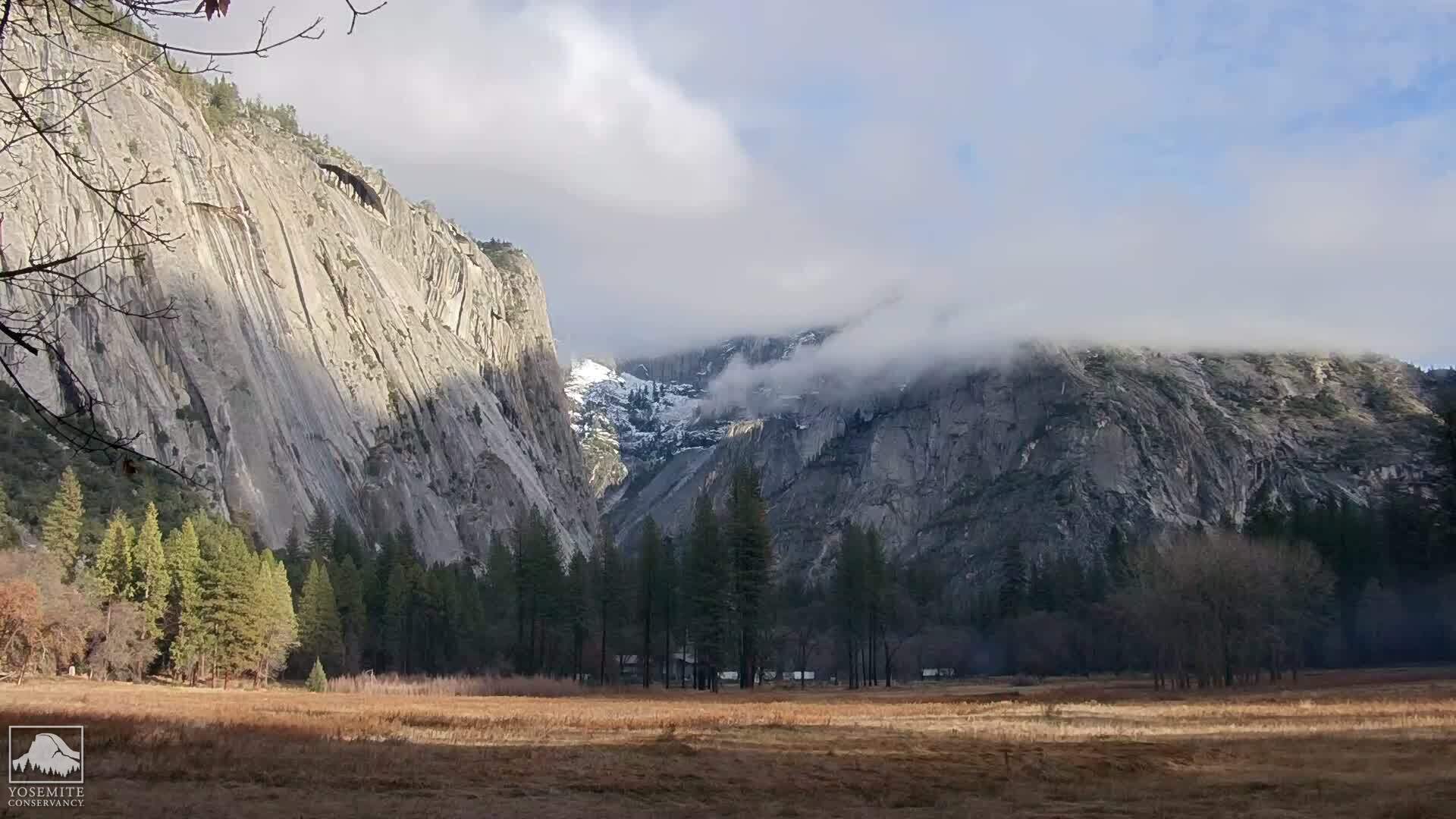
The view of Half Dome is obliterated by clouds.
The weather today is overcast, almost like a foggy San Francisco morning.  Would it clear up?  Would Half Dome's granite be dry enough to allow an ascent by the cables?  The only way to find out would be to hike there.
The contents of today's day pack are a little different than an ordinary hike. I have with me full water (three liters) and one liter of electrolyte today, lunch, trail mix, electrolyte gels, as well as rubber gloves and a climbing harness, with two runners and weight-bearing carabiners. (Not the kind of cute, decorative little carabiners that are served attached to an "El Capitini" at the Ahwahnee, but I digress.)  There is a spring where we can pump water a few switchbacks past the junction to Clouds Rest.  There are also some other ephemeral rivulets, but this is July so they can't be counted on.  Alan was carrying our water pump. 
We passed the warning signs at the beginning of the Half Dome trail, and started the series of interminable switchbacks that rise all the way up to the ridgeline.  A few switchbacks into the hike, Tirina decided to return to camp.  She wasn't feeling well, so Alan returned with her, after giving us the water pump.  Today's attempt at Half Dome would belong to Chris and I.
Half Dome - Clouds Rest Junction
We reached the Cloud's Rest junction withe no further event.  Such a different experience than when I hiked this trail in 2009.  I am now more physically fit, and because of the permit system, there aren't hundreds of people passing us up.  In fact, we are so early, that there are very few people on the trail.
When we get a few switchbacks past the spring, I am now in uncharted territory.  The switchbacks begin to level off as we reach the ridgeline, and the hiking becomes much easier.  I was amazed at how close we had come the first time.  Another difference:  there isn't a meat bee in sight!  Yeah!  I am unlikely to be attacked every time I try to take a bite of my sandwich.
Warning Sign at the foot of Subdome
A short while later, we reached the base of Subdome and its hundred - perhaps thousands - of granite steps, blasted with dynamite by federal workers in the 1930s.  The weather is still foggy, but it's not ominous or looking like it will rain.  No thunderheads that we can see or dark bottomed clouds.
Subdome is legendary for being the most physically demanding part of the Half Dome hike.  Most hikers are doing it in full sun, with no cover, and after having already hiked 7 miles with an elevation gain of nearly 4000 feet.  By contrast, we had hiked only 3 miles with an elevation gain of about 1000 feet.  We still had plenty of energy and, benefited by the cloud cover, reached the top of Subdome very quickly. 
Half Dome Cables, July 15, 2011
At the very top of Subdome, the granite steps have worn out and disappeared.  Making your way up the very steep granite, with nothing to hold onto, is very disconcerting.  Chris kept telling me to trust my boots, and as is my usual way, I just carried on.  When we reached the top of Subdome and started down the saddle that separates Subdome from Half Dome, we couldn't even see the cables or the top of Half Dome.  They disappeared into the clouds.  The big question of the day was whether the granite was dry enough to ascend the cables.  It turned out that it was, so Chris and I decided to make a go of it.
I stopped to rest and eat a little trail mix at the base of the cables.  Then I packed my hiking poles, and donned my climbing harness.  Everything on the outside of my pack was attached by carabiners.  I had heard too many stories and seen too many videos of people losing their hats, poles, water bottles and other paraphernalia while ascending the cables.  I not only didn't want to lose any equipment, I didn't want to be the cause of misfortune to anyone coming up behind and below me.  This is a great video from Mr. Half Dome (aka Rick Deutsch) of what it is like to go up the cables:

Rick literally wrote the book on the Half Dome hike and, although I wouldn't ever advise someone to hike outside of the cables, Rick has done this hike over 30 times and he knows both what he is doing and the risks he is taking.  I made my way up the cables carefully, slower than some and faster than others.  I had one carabiner clipped on to the cable, and as I reached a pole, I would clip the other carabiner to the cable above the pole, and then unclip the bottom carabiner.  It was slower to do it this way, but I was not going to take any unnecessary risks with a seven year old son at home.  Several of my fellow Half Dome hikers saw what I was doing and commented what a good idea it was and how they wished they had thought of that.  Even so, I met only one other person with a climbing harness that day.
Half Dome Summit
I found the cable section of the hike more physically demanding than Subdome, perhaps because I don't have as much upper body strength as younger or male hikers.  By the time I got 2/3rds of the way up the cables my arms were shaking, but except for that I didn't find it particularly difficult.  As I went up the cables, I saw water bottles slide down the face and a hat that had blown about 30 feet away from the cables and would have blown off the Dome had it not caught on something.  It might as well have blown Outer Mongolia, because it was nevertheless beyond anyone's reach.
Half Dome Summit, Above the Clouds
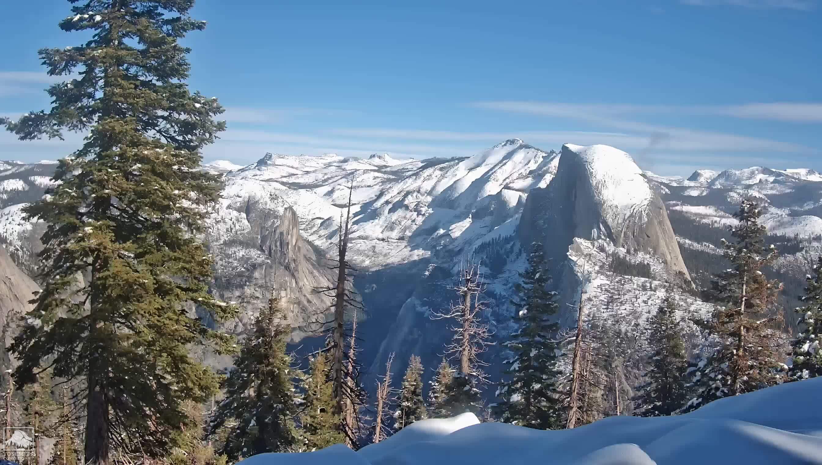
Just as we got to the top of the cables, the clouds began to clear, revealing a glorious day with 360 degree panoramic views of Yosemite.  It was lovely!  But was I really here?  I felt I need to pinch myself to make sure.  I borrowed Chris' cell phone and called Duane from the top of Half Dome. He was surprised to hear from me and so early.  I had no idea what time it was.  It turned out to be about 10:45 am.  We had made very good time, giving us plenty of opportunity to explore!
Marmot atop Half Dome
We sat down to rest and eat our lunch before exploring the top, and encountered marmots who, if given the chance, would happily steal your lunch!  We ate ours before they had a chance.

After lunch, we walked around the top of Half Dome for a while.  There is a dip in the middle, and this is where you want to go should you ever get caught in a lightning storm.  In 1985, 5 hikers foolishly hiked to the top of Half Dome in a lightning storm and were hit by lightning while they were hiding in the cave at Eagle's Beak.  Two of them died.  This incident was the subject of the book, Shattered Air by Bob Madgic.  It's well worth reading, not only for an understanding of what can go wrong, but as a chronicle of hubris.
Eagle's Beak,
4800 feet down to the Yosemite Valley
We gave our cameras to a fellow hiker, asking him to take a photo of us, and then walked out to Eagle's Beak for an iconic victory photo!  (You can see the cave in between us.)  Still, I could hardly believe I'd made it to the top!
Christina Sand & Chris Swartout, on Eagle's Beak


Hiking to the Northwest side of Half Dome Summit
I needed to walk around a bit more to convince myself that I was really, truly here!  So we walked over to the Northwest side for a gorgeous view of Yosemite Valley.  It's amazing how small Yosemite Falls looks from Half Dome.  The Ahwhahnee on the valley floor looks about the size of an ant.  In all, we spent about a half an hour at the top, enjoying the tremendous views and panoramic vistas.  It was truly wonderful!
Christina Sand & Chris Swartout,
Base of the Half Dome Cables
We started down the cables again, this time in full sun.  Still it wasn't hot, only warm, and that was fine with us.  The question was whether to go down face first or butt first, i.e., backwards.  I chose to go down backwards for a couple of reasons.  I didn't want to see the drop, and I also wanted the most control possible as I descended.  I wanted to be able to focus on what I was doing without the distraction of looking down and worrying.  I descended very quickly, so quickly I got to the bottom almost without realizing it.
Half Dome Cables
Finally, we could see what we had just climbed, and the view was yet another different slice of Half Dome.  Since it was still early in the day, there were very few people at the cables, even less so now with the permit system in place. We took one long, last look before continuing on down Subdome.

Top of Subdome, looking at Tenaya Canyon
Subdome proved to be harder on the knees on the way down, as I knew it would. The most disconcerting part was descending at the very top of Subdome, where the granite is nearly as steep as the cable section of Half Dome, but there are no cables or steps.  I walked down very carefully, making sure not to put my foot on sand over granite, following Chris and remembering to "trust my boots"!
The Base of Subdome
It was hotter than when we had come up and there was less cloud cover, but we still had plenty of water, electrolyte and trail mix, and our daypacks were now lighter for having consumed some of our supplies.  As we neared the base of Subdome, we began to see more and more trees.  We met park rangers on the way down who asked for our permits.  We hadn't seen them this morning because we got to Subdome ahead of them.
Edge on view of Subdome,
in front of Half Dome
We continued down the ridgeline, stopping to take one last spectacular photo of both Subdome and Half Dome.  We met hikers on their way up and gave them encouragement.  Amazingly, we found a rivulet that was still running, undoubtedly due to the heavy and late rainfall, and stopped to pump some water, rest and readjust our boots and socks.  This portion of the trail is lush and verdant and is probably my favorite portion of the Half Dome trail.
Chris Swartout pumping water at the rivulet


The weather continued to be in our favor.  The cloud cover had provided a respite from the sun for long enough that it never really got very hot.  It turned out to be perfect hiking weather Half Dome!   We were very blessed.  This time lapse video of July 15, 2011 shows the cloud cover.  When you see it break, that's the time that we had made it to the top.
When we got back to camp it was about 2:00 pm.  The day was barely half over!   Tirina was feeling better. I took off my boots, slipped on my camp sandals, crawled into my sleeping bag and took a nap, with a smile on my face.