This morning, I decided it was time to go to the top of Kennedy Trail. I've gone halfway twice for lack of time, and it was time to make time to get to the "top", i.e., the junction with Priest Rock Trail. This time I would be armed with my camera! Spring is definitely in the air.
We set out at 7:30 am and arrived at the trailhead a short time later. I forgot my fleece at home, but I didn't need it. I wore a short sleeve hiking shirt underneath a long sleeved hiking shirt, as I usually do unless the weather is really hot. It was cool and overcast due to the marine layer, but it wasn't cold.

The first couple of miles or so were done underneath the marine layer, but eventually we punched through. Not much of a view - other than fog - from the trail.
Spring, however, had sprung as I anticipated. The trail was lined with various types of wild flowers.
There was the usual
Scotch or Common Broom (
planta genista), an ubiquitous foreign weed bearing yellow flowers that is difficult to eliminate and takes over wherever it roots. (How it came to be called "Scotch" Broom in this area when it was associated with the Angevin (French) Plantagenet royal family, I have no idea.)

The orange blossoms of
Sticky Monkey Flower were also in evidence. Local native American tribes used to use the leaves to make a medicinal tea.
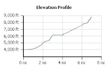
The Kennedy trail is not terribly long at only 4.1 miles, but it is steep. It is as challenging as the Stanford Avenue approach to Mission Peak, though with more shade. And, if you wanted to make it a longer hike, you could continue on past the Priest Rock Trail junction. Eventually you wind up on the Woods Trail and you can even take the trail up to Mount Umunhum (though not to the summit). I managed to catch the
California Poppy, native to California and its state flower.

We continued up the trail, though it was very foggy. We continued to see many beautiful wildflowers out in force.
Wild iris were abundant, as was
ceanothus (usually blue, but this time white) and
Blue Lupine. There was also a beautiful red
Indian Warrior. I could have picked a magnificent bouquet!


Eventually, we hiked through the fog and had a wonderful view of ... the marine layer. This is, of course, perfect hiking weather which only slightly makes up for the lack of a view. We continued to hike until we reached the tree - the halfway point in our hike.


We continued up the rest of the trail. There were fewer wildflowers in this hotter, drier part of the trail. As we neared the junction, the trail got quite a bit steeper. (Why does it always do this near a summit?) After a last steep section, we reached the junction - and sign.

Shortly after that, the fog began to burn off and we finally had a great view of the valley below! We turned around and hiked down the mountain - another conditioning hike under our belts!