Showing posts with label Liberty Cap. Show all posts

Thursday, July 14, 2011

Liberty Cap

Half Dome, from Little Yosemite Valley
Liberty Cap Hike
I woke up this morning, so sore that I didn't want to move.  The thought of putting even a daypack on my shoulders and hiking anywhere was simply not appealing.  But to the resounding chorus of my body's "No's", Chris very wisely urged me to get up and get moving.  I could stay in camp, he said, but if I did, it would be even worse tomorrow, the day we were scheduled to hike Half Dome.  Chris has done this backpacking trip about 19 times before, so when Chris talks, I listen.  I got out of my sleeping bag and got moving, brushed my teeth, got dressed, and made my breakfast of Cream of Wheat with raisins and nuts, and caffe latte.
Today's hike is unusual in that much of it is off trail.  There is no trail to Liberty Cap, the giant granite dome that sits in between Half Dome and Nevada Fall.  Perhaps for that reason, almost no one hikes there.  But it is worth it, not just as a conditioning hike, but also for the great views of Yosemite Valley and Tenaya Canyon.
Chris Swartout leading the way to Liberty Cap
In spite of my soreness, it felt great to leave behind my huge backpack, and take along my tiny day pack.  All I carried today was my peanut butter and jelly sandwich, one liter of electrolyte, some trail mix, and ~2 liters of water.  It probably weighed about 10 pounds - so much less than yesterday!

We set out back the way we came, towards Nevada Fall, except that half way there, we left the trail and started climbing up to the ridgeline.  From there we followed the ridgeline until we found "canoe rock". 

Canoe Rock
So far the hiking was relatively easy.   The trick is to not go too far or you wind up at Lost Lake, which can have lots of mosquitos.  Given the amount of rain this year, we didn't want to go there!  In fact, there was so much rain, so late in the season, that I have never seen the waterfalls running this fast and strong in the middle of July.  Usually by this time, they are down to a trickle.  Not this year.


Pussy Paws

Many wildflowers in evidence again today.  Indian paintbrush was in bloom, and also this fuzzy little pink flower, that is apparently called Pussy Paws.   This really is the strangest flower I have ever seen.  Very tiny leaves and the whole thing stays close to the granite.  I've never seen it anywhere else before.  My favorite, however, is the Mariposa Lily, truly beautiful!

Indian Paintbrush


I do not see the Mariposa Lily very often when I hike.  A few times in the Santa Cruz mountains and up in Yosemite.  So it is always a pleasure when I stumble across one.  About a third of all varieties are endemic to California, though apparently, early Mormon settlers in Utah ate the bulbs when their crops failed.  Perhaps for this reason, settlers made the local variety of Calochortus, the Sego Lily, the state flower.

Mariposa Lily
From Canoe Rock, the hiking got more difficult.  The abundance of rain this past winter grew a lot of waist high brush, that we had to walk through, much of it being very thorny.  At times, there was so much brush, we couldn't see all of our hiking companions, but they were always within earshot.  I was very glad for my long pants and my hiking gloves!  The hiking poles were less than useful at this point, so I put them away. 

The cleft on the backside of Liberty Cap
We could see the cleft in the back side of Liberty Cap that we would climb up - the trick was getting to it. We perservered. It looked rather steep, but there were ways to approach it that were less steep.

Another interesting find today was a damaged tree trunk that was oozing sap, which had dried in droplets as it fell of the trunk.  Cool!  Future amber?  I suppose it would have to be petrified...


Future Amber?
Once we reached the cleft, the climbing got more difficult.  We were clambering over giant granite boulders.  I was not always sure of myself, so I slowed down and picked my way through the boulders, interspersed with thorny bush, very carefully.  Little by little, we made progress.  The hiking here was more technical, less easy, and I was very glad to have padded hiking gloves on, which also served to soften the blows as my hands landed on immovable granite.  I wondered how I would get down, but decided to delay wondering about that until later.
Hiking up the cleft of Liberty Cap
At last, we reached the summit of Liberty Cap, and an expanse of granite warmed by the sun.  We sat down, and beheld the incredibly scenic vistas.  After a while, we unpacked and ate our lunch.  It was a beautiful day, about 76° F, mild and warm and, thus far, not too windy.

We could hear, but not quite see, the Merced River roaring over Nevada Fall.  Chris hiked down to an overlook, but it was so steep I chickened out.  All of us found comfortable places to rest and several of us took naps.  It was a really blissful time, with no one to disturb.

Mount Clark, from the summit of Liberty Cap
From the summit, we could see Mount Clark, named for Galen Clark, the man who came to Yosemite to die and wound up living until he was 96 years old.  We also had spectacularly clear views of Clouds Rest, which can be reached from a junction off the Half Dome Trail.  Clouds Rest is a much more difficult and strenuous hike than Half Dome, reaching a total elevation of 9,930 feet above sea level, much of the trail above the tree line and completely exposed to the sun and other elements.

Clouds Rest, from the summit of Liberty Cap


We would not do that hike on this trip.  Neither I nor Chris were conditioned enough to do it.  Another mutual friend did this hike with Chris in a previous year and wrote in his journal that "Today Chris tried to kill me."  Half Dome is enough for me, at least for the moment.  There are also other, easier trails to Clouds Rest.

After we were all well rested, we began the trek down the way we came.  Climbing over the boulders proved to be a bit more difficult on the way down, and I managed to put a few small holes in my brand new pants on a slab of granite over which I was sliding.

Funny that, even though I started out the day so sore, half way through the hike I was fine.  The soreness from yesterday's hike had vanished!


Half Dome from the summit of Liberty Cap
It never ceases to amaze me how many different views of Half Dome can be seen while hiking.  Trom the summit of Liberty Cap, we had another completely different view of Half Dome, tomorrow's hike, and the centerpiece of our backpacking trip. 


Wednesday, July 13, 2011

Backpacking on the Panorama Trail

Waiting at the North Pines bus stop
We awoke at 6:00 am, got a quick breakfast of cold cereal, broke camp, and readied our packs.  Because my backpack was so heavy, I only carried one third the usual amount of water for this hike, although I also had one litre of liquid electrolyte.  We planned to have lunch at Illilouette Fall, after which I would replenish water, if needed. 

Day 1: Glacier Point to Little Yosemite Valley
After breaking camp, we had to skedaddle to the shuttle bus by 7:00 am.  If we missed this bus, we would miss our connection to the Glacier Point bus.  Most of us were ready, but Chris wasn't quite ready, so some of us ran ahead just in case the bus came hoping that we could ask the driver to wait.  Fortunately, the bus was 15 minutes late so it turned out that we didn't have to worry at all!

Half Dome, from Glacier Point
We got to Yosemite Lodge in plenty of time to catch the Glacier Point bus, leaving us plenty of time to grab a sandwich for lunch or whatever last minute items we might want.  As for myself, there really wasn't anything I wanted to shop for.  Whatever I'd buy, I'd have to lug the whole way and, at this point, I was already 5 pounds overweight.  I would do my souvenir shopping after the hike was over!

Alan, Tirina and Chris Swartout and Christina Sand
Christina Sand and Half Dome from Glacier Point
The bus up to Glacier Point turned out to be a tour bus.  So our driver gave us the geology and history of Yosemite, including the native Americans who first lived there, and the Europeans who discovered it and how it came to become a national park.  This proved to be quite interesting, especially the story of Galen Clark, who discovered Mariposa Grove and who moved to Yosemite thinking he had six months to live after a diagnosis of tuberculosis, and lived there until the age of 96!  (Doctors do NOT know everything.)  The native Americans who lived in Yosemite Valley, a fierce tribe led by Chief Tenaya (for whom Tenaya Canyon and Tenaya Lodge are named), called themselves the Ahwahneechee (hence the Ahwahnee Hotel), but the Miwok called them "Yosemite," meaning "They are killers".

I also managed to catch a small cat nap on the bus during our two hour drive, when the bus driver wasn't telling a story.  We got to Glacier Point around 11:00 am.  Everyone took one final (flush) potty break, grabbed an ice cream, and hit the trail!
Panorama Trailhead
5.2 miles to Nevada Fall
The Panorama Trail begins at Glacier Point, and first descends into Illilouette Canyon via a series of long switchbacks.  There are many beautiful wildflowers to see along the way.  One of the more unusual flowers is White Ceanothus.  Blue Ceanothus is often seen on highway meridians, but where we live, I do not often see the white variety. 


Also in evidence was a beautiful purple flower that must be in the pea family, from the shape of its leaves and flower.

Several switch backs later, and we arrived at the  junction with one of the Merced Lake trails.  I was very glad to have my hiking poles, especially since my pack was so heavy that my knees almost buckled once or twice.  By this time, Half Dome was morphing into something less than its iconic shape, with the sheer face no longer visible.  We would see Half Dome from nearly every vantage point during our trip, with the exception of Nevada Fall, where it is blocked by Liberty Cap.  It still amazes me how one mountain can have so many different shapes.
0.9 miles to go to Illilouette Fall... and lunch


We were very fortunate with the weather.  Even though we went in mid-July this year, the weather was still mild and the temperature only 76 degrees.  Very nice weather for hiking!  No one wants to be hiking in 80-90 degree weather, especially witha 50 pound backpack!
Rhododendrons
We reached the bottom of Illilouette Canyon with Illilouette Creek roaring past us and under the bridge.  We stopped to eat our lunch, have a potty break, pump some water and rest for a little bit before making the 500 foot climb out of the canyon and up to the scenic Panorama Cliffs.  Always a good idea to readjust socks and shoes to ensure comfort and decrease the chances of a blister.  I've been very blessed.  Once I got the right hiking shoes, I've never had a blister.  At the river, as well as alongside the trail, we saw beautiful white Rhododendrons.
Yosemite Falls
from Panorama Point Overlook
After a little while, we put our packs back on, crossed the bridge and started the most difficult part of today's hike: the 500 foot climb out of Illilouette Canyon.   Illilouette Fall is not visible from the bridge; in fact, it's barely visible at all until you've crossed the bridge and gone much further along the trail.  Even though I have done this part of our hike twice before, the switchbacks up the hill still seem interminable.  Every time I think I'm almost there, I have a few more switchbacks to go.  Even so, I like hiking uphill more than I like hiking downhill.  It's easier on my knees.  And even though I'm not the fastest hiker, I can go on and one with little difficulty. 


Half Dome behind Liberty Cap,
from the Panorama Trail
Once at the top, the next part of the hike is quite nice, with incredibly scenic views.  There is an unmarked trail that leads to an overlook at Panorama Point.  It's a short detour and well worth the breathtaking views of Yosemite Falls.  Lots of wow factor on this trail!  A short while later, Liberty Cap begins to come into view and eventually will eclipse Half Dome, until we get to Little Yosemite Valley, our destination.

1.1 miles to Nevada Fall on the Panorama Trail
A few more miles and we reach the second junction to Merced Lake, which is much further up in the high country.  But at this point, we know today's hike is nearly over.  1.1 miles from Nevada Fall and that means we are 2.1 miles from our destination.  Woo hoo!  The next portion of the hike is a steep descent on short switchbacks down to Nevada Fall.  I am ready to put my feet in the cold water!  On the other hand, I am probably more inclined to carry on and get to our destination before we lose daylight and in order to get this heavy pack off my shoulders!

Chris and Tirina Swartout, and Christina Sand,
Nevada Fall
It's a gorgeous day and there are many day hikers who have hiked up to Nevada Fall from Happy Isles.  Lots of families with children and young adults.  Not as many of us with full packs on.  After a brief rest, and a photo opportunity, we continued on.

Such a different moment than when I unsuccessfully hiked Half Dome in September 2009.  On that day Duane and I were attempting a one day Half Dome day hike from Glacier Point.  We left late and by the time we got to Nevada Fall, there were literally hundreds of people there.  We went from the serene Panorama Trail to the insanely crowded trail between Nevada Fall and Little Yosemite Valley.  It was a real psychological downer.  As if that wasn't bad enough, I hadn't realized that the trail from Nevada Falls ascends around the base of Liberty Cap up hundreds of granite steps.  This time, I was more prepared for what lay ahead and, because of the new permit system and the time of day, it was much less crowded.  This was a blessing!  As I passed the base of Liberty Cap, I thought about how this was tomorrow's day hike.

Deer, Little Yosemite Valley
After reaching the top of the stairs, we hiked the last approximately half mile to Little Yosemite Valley, our campsite for the next several days.  Thankfully, the campsite has a pit toilet (solar composting for those of you who are "green"), but other than bear boxes to store food, there are no other facilities. At least we would not have to dig a hole with the orange shovel!

When we finally got to the camp and picked a site, we had a deer waiting for us amidst the fallen trees.  We set up camp, I put on my camp shoes, and we all relaxed, happy in the knowledge that we had successfully hiked our most difficult day!  (No, Half Dome is not difficult when hiked from Little Yosemite Valley with a 10 pound day pack.)  We had no trouble at all getting to sleep!  I had brought along J. Craig Venter's very engaging A Life Decoded, his autobiography, and listend to that for a while before going to sleep.  I had packed my Sansa Mini Clip MP3 player which was loaded with a few good audiobooks.  Paper is so much heavier than digital!

Saturday, September 19, 2009

Unfinished Business (Her Story)

The alarm went off at 3:00 am and the wake up call came shortly after - a real human being on the other end of the line. How nice to hear a human voice wake us up instead of a computer, but how awful for the person who has to be up at that hour to make those calls. Despite being tired the night before, I didn't sleep well. I probably got about 5 hours of sleep - not enough. Too many anxious thoughts running through my head.

I called the valet service to ask them to have our car ready in half an hour. Then I jumped in the shower and then got dressed. I put on my pants and immediately knew something was wrong. They were a tad too tight and then I realized - with horror - that I had accidentally packed Duane's hiking pants and not mine. They are exactly the same color - the only difference being the belt loops and the lack of a boot zipper at the bottom of the pant. Fortunately, we're about the same height and size, so they fit. Unfortunately for me, however, men's pants are cut narrower in the thigh. Although the pants fit, with every uphill step I would be fighting these pants. Subdome wouldn't just be difficult. It would be awful. I briefly considered wearing my jeans and quickly discarded that idea for a multiplicity of reasons. Duane's pants would have to do.

I was ready to go by 3:30 am, as we had planned. Duane was still packing his pack, which he hadn't done the night before. Grrr! By the time we left our room, it was 3:45 am. We were now 45 minutes later than I had wanted to be. I didn't get out of the parking lot, before realizing that I had left my National Park Pass in the hotel room. I ran back up to the room to get it. And then we were on our way to Glacier Point and the Panorama Trail trailhead.

It took us about 40 minutes to drive to Glacier Point. The road is currently gravel and torn up from Highway 41 to the turn off for Badger Pass ski area - about six miles. Fortunately, the road is graded well and is not badly washboarded. I was able to maintain between 20-30 mph on the dirt portion of the road, just under the regular speed limit. We arrived and parked near the outhouse. There were more cars than I expected - about eight vehicles - at that time of the morning. We parked and prepared our hiking poles, tied our hiking boots and put on our packs. Duane spent precious minutes repacking his backpack. I really didn't understand why this wasn't already done the night before. By the time he was ready to go, it was nearly 5:00 am, almost a full hour after we should have been on the trail.

One of the best things about being up at the wee hours of the morning at Glacier Point, was the heavenly view of the sky. We could easily see the Pleiades, Cygnus, Orion and the Milky Way. The sky was so full of stars that it was difficult to pick out familiar constellations. We could also see Venus just to the right of the black lump that had to be Half Dome. A beautiful sight, but we couldn't really stop at length to enjoy it, already being so late.

We found the trailhead and away we went. I wore two headlamps on my visor, but even though I was able to see, the lack of depth perception made hiking slower and more difficult. I didn't want to take a misstep and fall and hurt myself in the dark. Duane seemed to have better luck carrying his headlamp, but I knew that wouldn't have worked for me with both hands gripping my hiking poles. About halfway to Illilouette Fall, we could see the thin band of morning's first light breaking over the eastern horizon. About this same time, we saw pinpoints of light as if floating in the distance and lower across the canyon. This must have been other hikers on their way to Half Dome. It didn't get light enough to hike without head lamps until we reached Illilouette Fall, around 6:45 am.

For a while, we played the question game. Duane pulled a Reggie "Val Kilmer" moment. Marilyn Monroe was not appearing in films made in the 1970s (she died in 1962), nor was she as well known for her dramatic roles as she was for romantic comedies. No way I would have gotten that with the clues given.

After a short break to eat a trail bar at Illilouette Fall, we continue on across the bridge, up and out of Illilouette Canyon and to the Panorama Cliffs. At this point, rosy fingered Dawn was finally hitting the western peaks of Yosemite Valley. Beautiful! We decided to pass up a short trip to Panorama Point overlook. We had already been there in June and we were already very late. We continued on.

We reached the junction for the John Muir, and Mono Meadow at about 7:30 am. This was the first time we had seen any people at all since we started. One group of three passed us, followed shortly thereafter by two more hikers. The two hikers asked us if we were on our way down from Half Dome. What?!?!?! We pointed across the Canyon and told them that Half Dome was on the other side of the Merced River and pointed towards it. Half Dome, at this point, was mostly hidden behind Liberty Cap. We turned them around and set them on the right path. The group of three that we had passed earlier, came running down the switchbacks to Nevada Falls shortly thereafter. Apparently, they had also taken a wrong turn.

Why would anyone take on a hike as long and strenuous as the Half Dome hike without a good trail map? Inquiring minds want to know...

We reached Nevada Fall at about 8:15 am. We stopped at the restroom so Duane could use it. I tried to eat my sandwich, but was attacked by several yellowjackets. The last time I ate a lunch at Nevada Falls, the only critters that wanted my sandwich were squirrels. They were much cuter than yellowjackets! I gave up and put my sandwich away. I was amazed that there were so many people here at Nevada Falls this early in the morning. Oh what a difference that hour would have made!

A few minutes later, we continued on, past the restroom and up the stone steps around Liberty Cap, until the trail leveled out and followed the Merced River for another mile. Here the trail was so full of sand, it was like walking on a beach. It was actually much easier to walk just off the trail. There was actually a fresh trail cut by hikers, right next to the main trail, for this very reason. I used it.

Shortly before the junction for the Half Dome trail, we stopped at riverside to refill our water bladders for the grueling 3.5 mile trek to the top. After reaching the Half Dome Trail junction, we turned left and headed up the saddle between Half Dome and Cloud's Rest. We were about a mile past this junction, when we heard the loud distinctive sound of helicopter rotors chopping air. It had to be nearby. We looked up at Half Dome just in time to see the helicopter take off. Being out of communication, we weren't sure what had happened, but we knew that it couldn't be good. Flying a helicopter to the top of Half Dome is not done unless there is some kind of emergency.

I pulled out my small handheld transceiver (HT) thinking that I would use it to find out what was going on, but had forgotten that the Wilderness Protocol frequency - 146.52 on 2 meters - was programmed in my other HT and I couldn't remember the frequency. I put the radio back in my pack. Without that frequency, that hunk of plastic and metal was useless and I may as well not have brought it at all. We hiked on, though now a question mark had been cast over the day. What had happened on Half Dome?

At the same time, we were being passed by many hikers. Duane was getting more and more nervous and made up his mind at one point that he was not going to go on. He didn't want to try the cables in a crowd. I didn't either, but without knowing what was happening at the top, I didn't want to quit. I was angry with him. I had not come this far to beat myself mentally - or let him do the same. If there is one thing I have learned over this past year of training, it's that any endurance activity is as much a mental contest as it is a physical contest. My body might not hold up, but my mind wasn't going to give in. What I didn't read correctly was his sense of concern.

I reasoned with him that many of the people passing us would probably already be on their way back down by the time we got there. We estimated we would reach the cables by 12:00 pm, at our current, slower pace. I agreed that if it became clear that we could not get to the top and descend by 3:00 pm, we would turn back. He agreed to continue on.

At the same time, the weather was taking an interesting turn. The weather had been forecast to be 85 degrees and perfectly sunny. We checked my hiking thermometer and it was 80 degrees, though it didn't even feel that warm. But clouds were gathering over Half Dome, coming in from the west. We couldn't be sure, from this direction, what kind of clouds they were because they were partially hidden. Were they the beginnings of the dreaded cumulonimbus - thunder clouds that could immediately put an end to our hike? We weren't sure, but we paid attention.

We reached the two mile sign and the junction to the John Muir and Cloud's Rest trails. There were many people loitering, snacking and resting here. It was easy to find someone to take a photo of us. At this point, I zipped off my (actually Duane's) pant bottoms figuring it would be easier to do all the uphill. We hiked on. About ten minutes and a half mile later, we reached the spring. If we hadn't already known that it was a spring, we would have thought it was a puddle and hiked right on by. We hiked on for another several hundred feet up this series of interminable switchbacks.

By this time, we were beginning to see some hikers on their return. We stopped some of them to ask if they knew what had happened at the top. This was when we found out that it was a suicide. A few hikers later and we discovered that the cables had been closed and would be closed for approximately two hours. Hundreds of hikers were pooling at the Saddle between Subdome and the beginning of the cables. At this point, I knew that our Half Dome attempt was over. Even if we got to the top of Subdome by 1:00 pm, we would never get up and down the cables to Half Dome in the time that we had planned with throngs of people ahead of us at the Saddle.

At the same time, I was beginning to run out of gas and my appetite was so suppressed that I was finding it difficult to eat. I knew I needed to eat - I just didn't want to. I had to force myself to eat trail bars. My sandwich was out of the question. Duane had also tried to eat his sandwich, but was immediately attacked by five to six yellowjackets. He also gave up trying to eat his sandwich. I'm not sure whether my slight anemia played a part in this, but I'm sure it didn't help.

We were almost at the top of the ridge line, where we would have been at the tree line. We could see sky above the final switchbacks on the hill. We could see hikers going up the granite switchbacks on Subdome right in front of Half Dome. We could see hikers climbing up - or perhaps only down - the cables. So near and yet so far. We were disappointed. But I knew that in my current state of exhaustion, I would not be able to get up, let alone down, the cables safely. Neither of us wanted to hike back down tired and in the dark. So we turned around, going back over the ground we had so recently traversed.

The only constructive thing I could do at this point was to say a decade of the Rosary for the deceased (though I was so tired it was difficult to hike and count Hail Marys at the same time). It's difficult for most people to know what can drive a person to despair so deep that they see no value in their own life and no hope in the future. But I have known someone who killed himself. In his case, he had chronic depression, a kind of mental illness. Others I have had a passing acquaintance with had financial or family problems. None of them were bad people, but all of them were too proud to seek help. In their weakness they chose to throw away their lives.

Suicide is inherently a selfish act. One can never commit suicide without having an impact on the family and friends left behind. Sometimes that impact is a financial one. More often it is an emotional impact. It also impacts strangers, such as the hiker who found today's suicide or the postman who found my ex-boyfriend hanging from a rope off the balcony of his house in the middle of the forest five days after he had killed himself. It impacted the helicopter pilot who had to make a risky flight to the top of Half Dome to retrieve the body. It impacted all of the hikers trying to reach the summit, causing a dangerous logjam at the cables. And it impacted the deceased who will never again see another sunrise, another sunset, or another smile. So I prayed that, whatever his situation, God would have mercy and compassion on him and would help him sort this all out.

We returned to Nevada Fall, where we took off our boots and socks and, standing on the slick granite soaked our feet in the cool river water. It felt so wonderful. My feet were so hot, but fortunately not even a hint of a blister. Thank God for REI's generous boot return policy! It took four pairs of boots before I finally found the right size and this paid dividends today. We put fresh socks on and continued on down the mountain.

The next decision was whether to take the faster, steeper Mist Trail down the mountain or to take the longer, gentler John Muir Trail. We opted for the safer, surer John Muir Trail. Along the way down, we met two ladies who were both having knee problems. Duane gave them his extra knee strap and they gave us a bar of chocolate. That was wonderful and probably really saved me. I would never have thought to bring chocolate on a hike for fear of it melting and making a mess all over my backpack. But this was dark chocolate with less likelihood of melting. I wasn't hungry for much of anything, but I was still able to eat electrolyte beans and the chocolate was wonderful! My energy level picked up a bit. Even so, I was moving like an automaton over the rocky trail at this point. The last mile or two down the John Muir Trail was the most difficult, not because of the downhill which is harder, but because my energy reserves were so depleted.

At one point between Clark Point and the Vernal Fall footbridge, Duane fell down. I heard him start to go down close behind me, so I stopped and planted myself like a tree. He grabbed my leg and this stopped his fall, but not before he got a skinned calf and bumped elbow. We stopped, I pulled out the first aid kit and we disinfected his scrape and applied a bandage. We continued on.
We reached the Vernal Fall footbridge at about 5:15 pm. It was at this point that I drank the last of my water. Duane's hydration pack had run out about half an hour earlier, higher up on the John Muir Trail. Here, I made a much needed stop at the restroom and splashed cool water all over my head. (We still each had 32 ounce bottles of water remaining, however.) It felt wonderful! It was here that we met the curly, blond haired teenager and his friends who found the suicide's body and who called 911 on his cell phone from the top of Half Dome. He didn't seem too shaken up, but we were both sorry that this had happened to him.

We continued on, arriving at Happy Isles at a couple minutes past 6:00 pm - just after the snack stand had closed. Drat! But we were in time for the shuttle, which meant we didn't have to hike the last half mile to the Curry Village parking lot. Yeah! We reached the "welcome car" and changed our shoes and used the restroom at Curry Village. We decided to eat in Curry Village rather than wait until we arrived at Tenaya Lodge. We still had to pick up our other car at Glacier Point, so it would be at least two hours before we got to the hotel. We each had a hamburger at Curry Village. Yum! Then we hobbled to the "welcome car".

Neither of us were inclined to buy the we-made-it-to-the-top-of-Half-Dome tee shirt. So we took a pass. At this point, we both wanted a hot shower and bed.

It did indeed take another two hours to get back to Tenaya Lodge. I dropped Duane off at Glacier Point, traversing the six miles of gravel road once again though this time with much more traffic. He took some final photographs of Half Dome in the last light of the day.

We arrived back at Tenaya Lodge at a little past 8:00 pm. Duane showered and I soaked in a hot bath. I didn't have the energy to put on my swimsuit and head down to the hot tub. I could have fallen asleep in the bath. We ordered room service - we were both still a little hungry - and I ordered a margarita. We wound down a little bit before finally going to bed, sleeping like the dead.


Even though we didn't make the summit of Half Dome, we both felt that this was a big accomplishment. We hiked a further distance, over more time, at higher elevation than we had ever hiked before. We came within a mile to a mile and a half of the summit of Half Dome. Neither of us are twenty-something any more. Neither of us ever thought, in all the years that we have been visiting Yosemite, that we would ever have attempted to hike to the summit of Half Dome.

Saturday, June 20, 2009

Water, Water Everywhere

We set our alarms for 5:45 a.m this morning, but as it turned out it was unnecessary. Our son knocked on our door at 5:00 a.m. Our son and Uncle Dave were up early to see us off!

We showered, dressed and packed the final items in our packs. I packed my sandwich and we both filled our water bladders. I left a little bit of room in my hydration bladder and filled the rest of it with ice. That kept my water nice and cool for much of the day.

In doing all of this, I put my pack on my bed for a moment and when I picked it up a few minutes later, I noticed that there was some water on the bed. It turns out I had put the pack on the valve and released some of the water. I quickly cleaned it up while Duane gave me a hard time about doing this and reminded me to keep the valve closed. (He had done this at home about two months ago, emptying the entire remnants of his bladder onto our kitchen floor.) Duane meanwhile, had also put his pack down on the bed and, only moments later, noticed that he had a HUGE leak. (Uncle Dave named it "Lake Havasu".) Unfortunately, it wasn't just on his bed. The entire contents of his pack were soaked, including his spare socks. Apparently, the lid to the hydration pack had not threaded correctly. He quickly pulled the bedspread off the bed so that at least the mattress wouldn't get soaked, refilled his hydration bladder and this time put the lid on correctly.

Worse yet, he discovered this at 6:25 am, only five minutes before our shuttle was supposed to leave. We went downstairs, checked in for the shuttle and while we waited a few minutes for it to be ready, Duane unpacked his wet pack and dried the contents out and repacked, while I fetched him some dry spare liner socks from our suitcase. Fortunately, Duane didn't have his sandwich in his pack or that would have gotten soggy too.

We loaded our team, the Panorama #4 team, into two shuttles and headed off for Yosemite National Park and Glacier Point. About 40 minutes later, we arrived and, after some photos and an opportunity to use the bathroom, we headed off. Our son and Uncle Dave drove separately to Glacier Point to see us off. It was clear that they were going to have a really fun day together! Ten minutes and a few switchbacks down the side of the canyon and we heard two voices yelling "Bye" at us - our son and Uncle Dave waving at us from Glacier Point. That was really cool!

Almost immediately after we started our hike, we noticed a bush with white blossoms. Our guide Roddy told us that it was Whitethorn. I thought it looked an awful lot like Ceanothus, except that it wasn't blue. It turns out that Whitethorn IS a white Ceanothus.

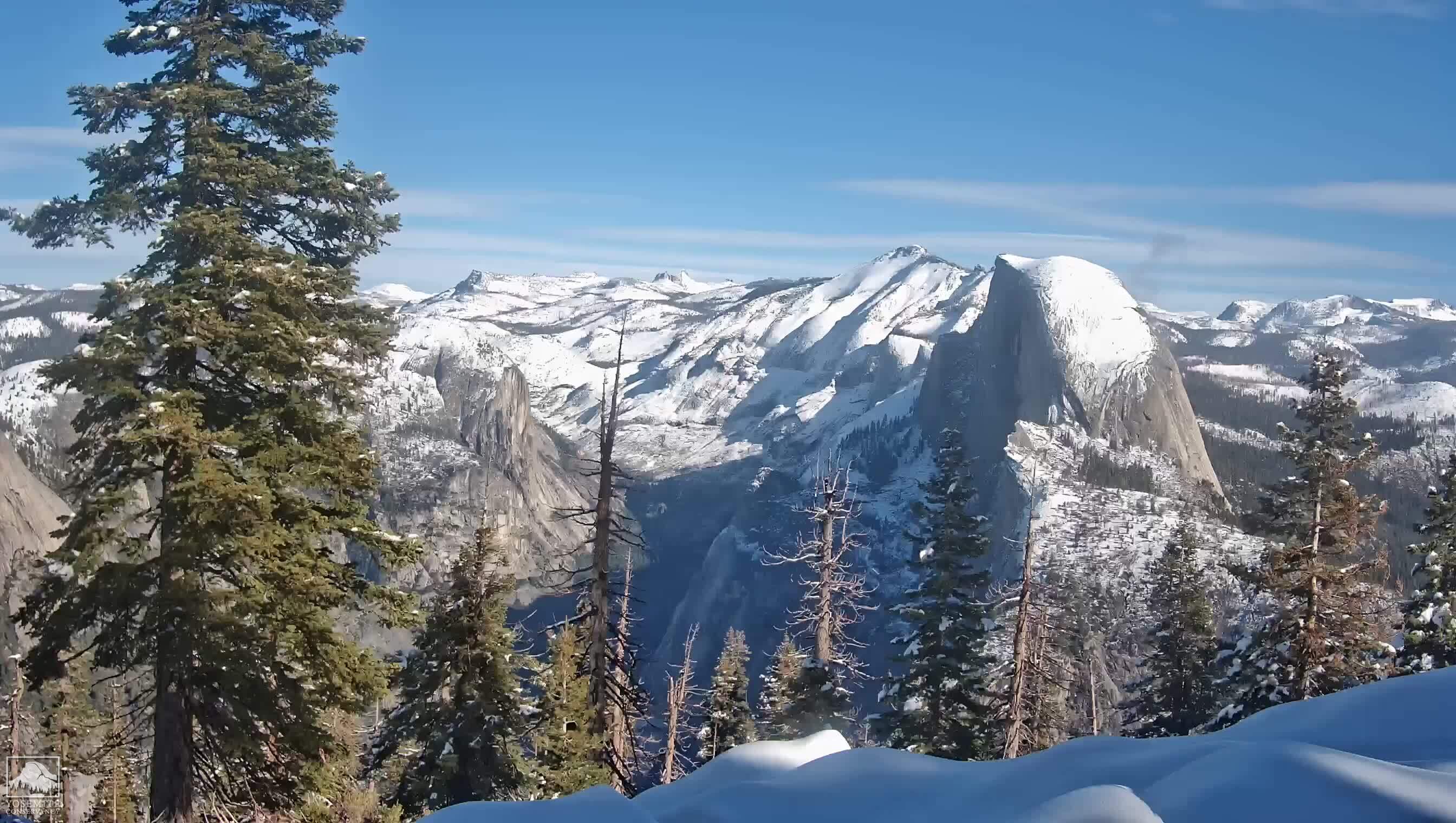
The view of Half Dome, where several of our teammates were hiking, is much more imposing and intimidating from Glacier Point (seen above with Vernal and Nevada Falls to the right) than it is from the valley floor. I must admit to having mixed feelings about not making the team, especially after what happened last week. Fortunately for our teammates, the weather is perfect. Not too hot and no rain. They will have a good day.

The first stretch of our hike was mostly down switchbacks, not terribly steep. We made it to the first junction and the group was still mostly together. By the time we got to the junction of the Panorama and Buena Vista trails, about 2.6 miles into our hike, one of our teammates was falling seriously behind. We waited about half an hour at that junction for the group to come together before trekking on. This teammate apparently didn't participate in most of our training hikes - so much so that I didn't even realize this hiker was on our team. Apparently, this hiker had an issue with blisters and, to make things incredibly worse, had chosen not to wear the hiking boots that had been left in the car. Instead, this hiker wore ordinary tennis shoes. No hiking poles either.

On a short hike, this might not make much of a difference. But on a longer hike with a lot of downhill, this was a stupendously bad idea. The tennis shoes did not have enough room in them at the toes for all of the downhill we were doing. Consequently, this hiker was jamming toes into the end of the shoe and will probably lose both big toenails and perhaps others as well. This teammate hiked the last paved mile from the footbridge to Happy Isles in stocking feet.
Similar problems had happened to me earlier in the season and I was not unsympathetic towards this hiker. I was unable to finish our Windy Hill hike. That's when I discovered that my boots were too small and that I needed an orthotic to prevent problems with my metatarsal arch. As of today, I am on my fourth pair of hiking boots, but I sorted these issues out months ago and I kept at it until the problem was solved.

There is apparently a requirement that all Team in Training hike participants wear appropriate hiking boots for our last and longest two hikes and also for the event. So why this hiker was allowed to participate with inadequate gear doesn't make any sense to me. Where was our coach who was acting as the sweep on our hike? Didn't she notice? And what about the officials who were taking check ins? Tennis shoes would have been fine for the easy, level Valley Floor hike, but not for a 9.6 mile hike with a 3,179 ft. elevation drop!

The immediate consequence for the rest of the group was that we had longer and longer waits for this hiker to catch up at the trail junctions. By the time we got to the Vernal Fall footbridge, just past the junction of the Mist and the John Muir trails and nearly at the end of our hike, we were waiting about an hour. Our muscles started to cool down and tighten up and we had to keep stretching. Our hike, which should have taken between five and six hours, instead took about eight.
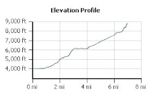
But even that couldn't ruin the glorious day that we had. The weather was perfect and the temperature never rose above 80 degrees. We hiked down to Illilouette Creek and crossed the bridge, reaching Illilouette Fall a few feet later. Illilouette Fall can not be seen from the bridge or even from just above the Fall - we had to view it on our way down to the bridge. We dawdled a bit at the bridge before hiking our one incline of the day (about 700 feet) out of Illilouette Canyon and on to Panorama Point. Panorama Point has incredible vistas of Half Dome, Yosemite Valley and the Merced River. Awesome!

After Panorama Point, we pressed on along mostly level terrain until the junction of the Panorama and Mono Meadow trails. From there we descended a series of switchbacks down to Nevada Fall. Wildflowers were in evidence throughout the day, with the best specimen being the wild azalea that we saw just before reaching Nevada Fall. They were wonderfully fragrant, reminding me of the perfume of star jasmine or wisteria.

We stopped at Nevada Fall for lunch (would someone please remind me NOT to put avocado on my sandwich when I order it the day before). There was also the opportunity to use the bathroom conveniently located slightly upriver from the Fall. We had wonderful views of Liberty Cap and the Merced River, while eating our lunch.

Roddy, our trail guide, had been given about five pounds of M&Ms and trail mix to carry in his pack. Why, I wasn't sure, since we all had our own food. Apparently, people didn't bring enough food last year, so this year the guides and everyone else over corrected. So poor Roddy had to carry all that extra weight the entire hike and, of course, he took every opportunity he had to offer us M&Ms. We obliged as we could, but refrained from giving any M&Ms to the two squirrels who befriended us during lunch.

Of all the trails we have hiked over the past several months, this one had the most bathrooms, located at Glacier Point, Nevada Fall and the Vernal Fall footbridge. I think there was one at Vernal Fall too. Ironically, I didn't need to use any of them, which was even odder considering that I nearly always need a bathroom about ten to fifteen minutes into a hike. Go figure. I must have calculated my liquid and electrolyte intake just right. I drank a 32 ounce bottle of Gatorade on the first half of the hike and another 32 ounce bottle of Gatorade on the second half of the hike. In between I sipped water out of my hydration pack. By the end of our hike, I had almost no fluids left. Perhaps, being at higher and drier elevations, my body also knew that it needed to use more fluid?

My equipment was also working well. My hiking boots were comfortable all the way to the end of our hike. My newly purchased sweatband worked wonderfully, keeping my forehead nice and cool while at the same time keeping my glasses dry. The water-laden neckerchief that I had purchased was refreshingly cool on my neck and I was glad to have it along.

Oddly, our group was composed of several teammates with injuries. Duane had a knee injury earlier in the season as did another of our teammates. A different teammate was recovering from a broken collarbone. And there was our hiker with toe issues. But most of us had been training for Half Dome and were in pretty good shape despite all, remaining at our near the front of the pack. Duane's knee didn't bother him the entire hike - his knee strap did its job.

After lunching at Nevada Fall, looking at the Fall from the observation point and taking several photos, we moved on. At this point, we made the decision to take the John Muir trail down to Happy Isles, rather than the Mist trail. The Mist trail goes right next to the waterfalls and is composed of two runs of large granite steps cut out of the side of the canyon. Going down the John Muir's more gradual switchbacks would be easier on the knees and feet than the Mist's granite staircases, despite the extra half mile, and we already had one hiker with serious feet problems.

As we descended down the John Muir Trail, we were passed by a few mule trains which left their smelly droppings along the trail. We hadn't encountered these during our April hike to Vernal Fall, most likely because portions of the trail were still covered with snow and it was too early in the season. Despite this odiferous portion of our hike we had a stunningly glorious view of Nevada Fall on the way down, hiking under an overhang dripping with snow melt. Very refreshing, but we had to watch out for our cameras!

By the time we got to Clark Point, all was beginning to look very familiar albeit with less snow than there was last April. Only 1.7 miles to go! We hiked down this last portion of the hike reaching the junction of the Mist and John Muir Trails. Our guide Roddy decided to wait at that junction for the rest to catch up and told the rest of us to proceed a short way down to the Vernal Fall footbridge. It was a nicer place to wait, complete with bathroom, drinking faucet and a place to wash off the dirt. We waited there for about an hour before hiking the last bit to Happy Isles.

At Happy Isles, we caught the shuttle bus to Yosemite Lodge, where we were to check in from our hike before catching our vans back to Tenaya Lodge. I stopped in at the general store and purchased a six-pack of Bud Light, which I shared with our teammates. Our hiker with the foot problems was very happy to be back and I was glad to offer my congratulations with a beer! On the way back to Tenaya Lodge, we stopped for a bathroom break and I finally had the desire to unleash what was left of the pent up fluids I had consumed earlier in the day. Ahhh!

We had an hour and a half to shower and change into fresh clothes, after reaching the lodge and reconnecting with our son and Uncle Dave. Felt so much better! I wasn't much sore this evening, despite the length - and duration - of our hike. This trail really wasn't very challenging. But, oh, what gorgeous vistas! At 8:00 p.m., we went to the Celebration Dinner, where we ate a pretty good meal and even had enough energy left over to dance some swing. After dinner, I soaked in the jacuzzi for an hour with some of our fellow hikers, sharing stories of the day, before turning in for the night.

What a wonderful day!