I may have found the answer to the reason for my decreased appetite. I did my final blood test on Monday after the hike and found out today that my anemia is probably related to iron deficiency, in turn caused by a hormonal imbalance. Iron is the precursor that the body needs to form hemoglobin. Hemoglobin, in turn, is the oxygen carrying molecule contained in red blood cells.
Fatigue and weakness are symptoms, because the body's tissues aren't getting enough oxygen. Apparently, decreased appetite is also one of the symptoms of iron deficiency anemia. So this may be the reason why I've been having to force myself to eat while hiking.
How annoying that this happened right before our Half Dome hike!
I thought it was weird that I couldn't keep up with Duane last Saturday. I have never been unable to keep up. I'm usually in the lead. I wasn't having a problem during our final conditioning hikes, though I wasn't at as high an altitude either.
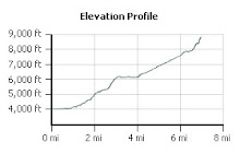
Feather Falls is somewhere around 2900 feet elevation. Black Mountain is at about 2800 feet. Saratoga Gap is lower at around 2400 feet. Mission Peak, which we did earlier in the Spring - twice in one day - was 2517 feet. We did the Panorama Trail down to Happy Isles last June and I had no problem at all and had plenty of energy left at the end of the hike. I was at the front of the pack the whole way. During our Half Dome hike I was anywhere from 7200 feet elevation at Glacier Point, down to about 6000 feet at Nevada Fall, and back up to 7300-7500 feet elevation where we finally turned back.
The only surprise for me is the relationship between iron deficiency anemia and appetite. I expected that the anemia could be a problem. I'm nevertheless annoyed.