Sunday, April 3, 2011

Up the Kennedy Trail - Redux

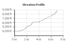
A very busy day today, but squeezed in another conditioning hike up the Kennedy Trail with Chris. This is quickly becoming our favorite training ground, because of the elevation gain, but also because it provides more cover than do the trails up Mission Peak or in Alum Rock Park.

Unfortunately, I left my camera at home today so was not able to take any photos. There was a much better view than last time!

As with the first time I hiked the Kennedy Trail, we didn't go all the way to the road but to the tree that marks the approximate half way point.

Sometimes there just aren't enough hours in the day, but at least some conditioning is better than nothing!

Saturday, March 26, 2011

Mud Run 2011

After the fun we had last year, my friend Deb, as well as my brothers John and Stephen and my sisters-in-law Sandi and Rose, decided to do the Big Sur Mud Run together. Unfortunately, I've been so sick with the flu that I haven't really had the energy to train. About a month ago, my whole family came down with the worst flu we've ever had. Our son had fever spiking to 104 for five days, and although Duane and I didn't have a fever that high, we both got really bad ear infections. Ugh. I was hoping to do better than last year's time, but at this point, I'm just glad I'm feeling well enough to do this!

We drove down to Marina the night before and stayed at the Ramada just as we did last year. Unlike last year, however, the weather was wet with a light rain falling during part of the run. The Army didn't have any need to add water to make mud this year. All they had to do was dig holes and let the rain do it for them!

Some runners covered their clothes with plastic garbage bags. I wore a hiking hat with a broad brim to keep the rain out of my eyes, some exercise tights, a tee shirt and a waterproof parka so I wouldn't need to use a garbage bag. Runners were milling about the big red arch at the start line. We had some warm ups at the start, before the gun went off and when it finally did go off, off we went!

It didn't take long for me to lose everyone in my group. I had thought I might be able to keep up with my little brother, since he has been having some difficulties with his feet. Apparently, this didn't stop him much because after the first few minutes, Stephen was no longer visible. I tried looking for the umbrella hat that my sister-in-law Rose was wearing. That was not to be seen either. I was all by myself in a crowd of hundreds. So I just kept jogging along.

The course was similar to last year, but there were fewer obstacles. The walls seemed to be shorter by a foot. Or at least it seemed that way since, this year, I had no trouble surmounting them. Running downhill was more problematic with all of the slippery mud and I found myself being more careful. There were also three calisthenic stations, at which Army drill instructors commanded us to do push ups, jumping jacks and sit ups. I kept moving through the various stations and obstacles and still I never saw the rest of my group.

Finally, I got to the last wall and mud pit. I heard the announcers voice joke that someone wearing "Avenger gear" was moving through the mud pit. Was he talking about me? I was wearing a broad brimmed hiking hat...

A few minutes later, I was running the last lap around the track before the finish line. I had been running pretty casually (where was everyone?), so I decided to sprint for the finish line. It was just about then that I noticed everyone was waiting for me. I wasn't surprised. My time was 1:21:13 - not the greatest and only 45 seconds faster than last year's time... but it was faster!

We finished off the day with a great seafood lunch at a Monterey restaurant after showering and changing into clean clothes. The question remains: Will I do this again next year?

Sunday, March 13, 2011

Back to Alum Rock

Today's hike was a short one at Alum Rock Park, mostly because of time constraints. My friend Chris and I hiked up the North Rim Trail to Eagle Rock and back. When we have more time, we'll hike up to the Santa Clara County Open Space Authority, which goes the rest of the way up the side of the canyon.

I'm still using my day pack, though I'm starting to load more weight in it. I can add 6.6 pounds just by carrying the three liters that my hydration pack will take. Add to that some trail mix, a bottle of G2, a camera, assorted odds and ends, and the pack is probably close to 12 pounds. Not enough weight, but it's March and we still have three and a half months to go before Half Dome.

We didn't see too many wildflowers today. It's still early and the weather has not cooperated. But we did see some beautiful purple Vetch. Vetch is in the legume family - you can tell because the leaves are similar to what you would see if you grew your own peas.

Eagle Rock is always an interesting destination, not just because of the rock, but also because that location is also the site of a local amateur radio repeater and other antenna installations. And it has a great view of San Jose too!

Monday, February 7, 2011

Up the Kennedy Trail

This morning, a friend took me on one of her regular hikes. She likes to run up the Kennedy Trail in the Kennedy-Limekiln Area, within the Sierra Azul Open Space Preserve, where I was last weekend. In fact, if you get to the top of the Kennedy Trail, it connects to the Woods Trail that we hiked.

The day was misty and rainy. I dressed for rain, but was fortunate in that it only came down for about a half an hour of our hike. The rest of the time it was just the very damp mountain mist. Still wet, but at least it was not a soaking. The Woods Trail only gains elevation of about 1100 feet, while the Kennedy Trail goes right up the mountain side for an elevation gain of 2000 feet. It is a fire road, so you would expect it to be steeper than a footpath and it is. This made for quite a vigorous workout!

The altitude also offers many beautiful views, but unfortunately, my camera was not at the ready. This is, however, a challenging trail and I would like to hike it again on a sunny day when I have my camera and don't have to depart early for other appointments.

Saturday, February 5, 2011

First Hike of the Season: Sierra Azul O.S.P.

So nice to start hiking again after all the rain! Today's hike was at Sierra Azul Open Space Preserve. We decided to hike the Woods Trail, which is really a fire road that begins just off of Hicks Road, up to Barlow Road, another fire road that continues up to the summit of Mount Umunhum.

This hike is 5.4 miles round trip with an elevation gain of 1100 feet. As we started down this trail, I began to wonder where the elevation change would happen because for the first third of the trail, we continued further and further downhill - until we reached Guadalupe Creek.

This river was discovered and named Rio de Nuestra SeƱora de Guadalupe (River of Our Lady of Guadalupe) by the De Anza expedition in 1776, in honor of the patron saint of the expedition. Guadalupe Creek feeds into Guadalupe Reservoir, which is one of the reservoirs which supply the Santa Clara Valley with water. The outflow from this reservoir becomes the Guadalupe River, which runs downhill through San Jose before it drains into the Bay, has been the cause of many floods in the Willow Glen and downtown areas over the years. For this reason, the City of San Jose is currently working on flood control projects on this river. But at this point, the Guadalupe Creek is small and hardly seems dangerous.

On our way down to the creek, we came upon the remains of at least four lizards which had somehow met their demise on the trail. We wondered about this and ultimately decided that they came out to warm themselves in the sun, only to discover a temperature colder than their bodies would allow. Maybe. Maybe not. But it sounded good! We nicknamed this trail the "Frozen Lizard Trail".

The creek was a wonderful opportunity for our son to throw some large rocks off the bridge and into the pool below. Splash! After that, we began our ascent - at last - up the mountain. On the way, our son collected several rocks, including some nice quartz specimens, that appeared to have been brought in as gravel for the fire road.

As the trail climbed away from the creek, we began to have some really great vistas of downtown San Jose and the rest of Santa Clara Valley. Beautiful! Also as we continued to climb, we had close up views of the former Almaden Air Force Station radar tower - the big square structure on the summit of Mount Umunhum. This was an early warning radar station that operated until 1980. I've always thought it would be an interesting place to visit, but the area is closed due to toxic substances and mold. Also near the summit is the Bay Area NEXRAD weather station - the white spherical structure that is an advanced Doppler radar.

Power lines also cross this trail, as they do the PG&E Trail in Rancho San Antonio Park. Here the powers lines make a sweeping catenary arc across the canyon - in view just before rounding the point. Here there are grand views both of Mount Umunhum, the Santa Clara Valley, as well as Mount El Sombroso.

The end of winter was beginning to be in evidence. The first spring wild flowers were beginning to bloom, as well as some tree flowers. I wondered that more rain would come in March, however, as it usually does. Some very pretty succulents were also in display alongside the trail.

We reached Barlow Road, took a break to hydrate and have some trail mix, and our son played with rocks and sticks, before we began the journey back to the trailhead. What a beautiful day!

Friday, January 28, 2011

Half Dome or Bust

We have received our wilderness permits for Yosemite. This year we will be departing the trailhead in mid-July, which should give the snow plenty of time to melt!

Half Dome, here I come!

Of course, it's now time to make best friends with the Stair Master...

Saturday, November 6, 2010

Kicking the "New Tires" at Butano State Park

I've hiked only once since the Pinnacles last May and that was a short hike up the Pipiwai Trail in Maui's Haleakala National Park. So I've been eager to "kick the tires" of my new body and try it out on a longer hike. I planned a hike up to the summit of Mount Diablo for tomorrow, but when the forecast came up rain, I decided to go with other friends to Butano State Park today.

I also decided to try out a new pack system: an extremely large fanny pack, with two 1 litre Camelbak bottles with hoses, one on each side. Since today's hike was supposed to be a short hike, about 4-6 miles, it would be a good day to try this out. I packed one litre of water, one litre of G2, and a bag of trail mix. I didn't bother to pack a lunch since we were going to Duarte's afterwards. I still have 18 pounds left to lose and didn't want to screw up my diet even though hiking.

Several of us gathered at my friends' home at 8:15 am, and carpooled over to Butano State Park, which is near Pescadero. We arrived at the trailhead at about 9:15 am and prepared for the hike. A few minutes later a larger group of hikers also arrived. It would be a good group today!

We started out on the Ano Nuevo Trail, which took us immediately up a steep, verdant redwood canyon. 1.3 miles later, we joined the Olmo Fire Road that took us nearly to the top of the park. Everytime you walk on a fire road, you know that it's going to be steep and hard to climb because the fire roads are built and graded for vehicles and also because there is gravel that can make walking difficult. For the most part, we walked through the damp, redwood forest and were privileged to see one of the park's famous newts on the trail.

The fire road took us out of the redwood forest up to the ridge line, redwoods giving way to pines, other conifers, and sandstone bluffs. This portion of the fire road just before reaching the ridgeline was quite steep. From the ridgeline, there were tremendous views of the Pacific Ocean and the Santa Cruz mountains.

We turned off onto the Indian Trail and headed a little over half a mile to the junction to Trail Camp, where backpackers can camp overnight. There is an outhouse, racoon boxes, and some garbage cans, but not much else. Another third of a mile and we reached the abandoned air strip near the top of the park.

This gravel airstrip looked like it might come in handy to the California Department of Forest in the event of a fire. We found a shady spot and sat down to eat lunch. At this point, it was already noonish, and we had covered about six miles and we still had to go back. My friend's calculations about the length of this hike were obviously off. So I ate my trail mix, saving a little for the journey back.

After about half an hour's rest, we headed back down the mountain. When we reached the junction with Indian Trail, this time we turned right, heading the opposite direction. In contrast with the fire road, Indian Trail is quite narrow - in some places no more than 1.5 feet wide. This sometimes made hiking with poles a bit difficult as the mountain dropped off sharply to the left and we were sometimes walking through thick brush. There was poison oak everywhere, though it was easier to identify as it was often shades of yellow and red. Fortunately, this time I was mercifully spared its ravages.

From the Indian Trail, we hiked onto the Jackson Flats Trail. Now we were again deep in redwood forests, hiking alongside the canyon. The trail here began to widen out a bit making the journey a bit less difficult. This trail took us back to the parking lot, which we reached at about 4:15 pm.

I was a bit sore, but none the worse for the 12.5 miles that I hiked today. I slowed down a bit at the end, but I could have kept hiking another couple of miles if I had had to. I was less than thrilled with my large fanny pack. The bottles sit too wide and do not allow my arms to swing freely - they kept hitting the hoses. I may be able to fix this by buying some hose clips. I'll give it another try. It did feel quite different to have my shoulders free. I probably need to reseat the fanny pack properly over my hip, which was suggested by the tightness in my right gluteal muscles. But all in all a very good day.

At this point, however, I was really hungry as I hadn't eaten a proper lunch. We stopped at Duarte's for dinner, but as I was going to go out with Duane for date night, I couldn't eat dinner. I tied myself over with an hor d'oeuvre, then carpooled back home, later than I thought, but still in time for date night.

Friday, September 10, 2010

Running on the Treadmill

I've always hated the treadmill. It's boring. You walk/run going nowhere. It always conjures up visions of a rat running on a wheel. That and I've never really been able to do more than a fast walk.

Nevertheless, I thought I would give it another try. After losing 33 lbs., why not? So I hopped on and set the machine to a speed of 2.5. Too slow. I increased it to 3.0. That was still too slow. I increased it again... and again.... until I reached 5.0 and was running with the maximum amount of incline.

I kept waiting for something to hurt or to get winded, but it never happened. I was still running after a full 30 minutes. Wow!

Thursday, July 29, 2010

The Road to Hana... is Paved With Waterfalls

Keopuka RockBesides sunrise over Haleakala, I also missed driving the road to Hana on previous trips to Maui. The first time I was here, the road was still a poorly graded dirt road which was so difficult to drive that people made a living off of selling "I survived the road to Hana" t-shirts. On subsequent trips, it just wasn't something that we made time to do because the drive takes an entire day. Although the distance from Kahului to Hana is only about 52 miles, the road is very curvy with dozens of one lane bridges so it takes at least 3 hours to drive one way - not counting all of the things to stop and gawk at along the way.

Jade VineNow we had time and my curiosity, having already been piqued, we decided to do it. Fortunately, we didn't have to leave quite so early in the morning as we did for the trip up to Haleakala and were able to go at a more leisurely pace. Once past Kahului, we started on the Hana Highway. Our first stop, at about 10.5 miles and in between Kahului and the Keanae peninsula, was the "Garden of Eden", a botanical garden and our first walk of the day. We roamed the trails here looking at beautiful tropical flowers, Keopuka Rock (which was featured in the opening scenes of Jurassic Park, and Puohokamoa Fall.

Keanae PeninsulaA short distance further, around Mile Marker 12, we reached the Keanae Peninsula. The views here are incredible, and we found a spot to pull over so we could gawk and take photographs of the high surf hitting against the black aa. This peninsula was created by massive lava flows from Haleakala crater. There was a small village located here, which is now much smaller due to the tsunami that hit here on April 1, 1946, killing 24 people. The only building to survive was the Congregational church, still standing. Besides beautiful views of the surf, we also saw many lush taro fields.

Waikani FallsOur next stop was halfway between mile markers 19 and 20, at the beautiful Waikani Falls, also known as Three Bears Falls. We stopped by the side of the road, to view the lower falls and took a look at the steep trail before deciding against clambering down all of the slippery rocks. We would look for better hiking further on.

We drove on until reaching Pua'a Ka'a State Wayside Park, around mile marker 22. This park was actually more promising for a real hike. After viewing the lower falls, our guide book said that if we climbed up a short trail on the other side of the river, we would find another, more beautiful waterfall.

Lower Pua'a Ka'a FallsThat trail had, since the book's printing, obviously washed out. You could see where the pavement ended rather abruptly into mud. We started climbing what initially looked like a dirt trail, however, it became clear about halfway up that we were actually in the creek bed. While climbing, one of my feet came out of its shoe. Fortunately, I managed to put it back in the shoe before stepping in the mud. We all got very muddy here, nevertheless. At the top of this small hill, we reached a dirt road.

aqueductWe continued down the dirt road to the left and, almost immediately, came to a small, steel footbridge over an aqueduct. This area gets most of the rainfall on the island and is prime watershed. A series of pipes carry water from this part of the island to the rest of the island. This small footbridge was the most difficult portion of our hike, and somewhat dangerous, but we all made it over. We resumed the very muddy trail on up the hill and a short time later arrived at Upper Pua'a Ka'a Falls.

Upper Pua'a Ka'a Falls and mudIt was worth it! This waterfall cascades over the precipice into what must have once been a lava tube, but has eroded away leaving the harder shell, leaving only a beautiful, round pool of water. The beauty of this setting was definitely worth the copious quantities of mud we had to endure to get here.

On the way back down, we decided to follow the dirt road to see if there was another way down to the road, instead of taking the same muddy way back. This dirt road apparently belongs to the East Maui Irrigation company, so we figured they must have a way down. Shortly past the turn off to the muddy way we had come up, we found a nice - dry - dirt road that took us almost directly back down to the road. If only we had known on the way up, we could have avoided the mudding that we all got!

Upper Hanawi FallsWe continued on until just past mile marker 24, when we reached Upper Hanawi Falls. This particular waterfall is spring fed so it runs year round, though it is at its most impressive after a good rain. Although not the rainy season, we had had some rain the day before and it was threatening to rain more today, so the pool was full of water and a relatively good flow could be seen. We declined to take the steep downhill trail to Lower Hanawi Falls, as we wanted to continue on to Hana ... and beyond.

Our next stop was at Kahanu Garden, a short drive just off the Hana Highway at mile marker 31. Kahanu Garden has the world's greatest collection of breadfruit, and more beautiful flowers, but this isn't its main attraction. The centerpiece of Kahanu Garden is the Piʻilanihale Heiau, the remains of the largest ancient temple in the Hawaiian Islands. It was begun in the 14th century, about the same time that the great cathedrals of Europe were being completed, and was finished in the 16th century by Chief Pi'ilani after he unified the island of Maui. This massive temple is built on top of a lava flow out of basalt and takes up about 3 acres. It's hard to grasp the immensity of this building from the ground. Fortunately, aerial photos of the temple give us a better idea of its scope.

Pi'ilanihale Heiau
PlumeriaAfter about 45 minutes of walking through the gardens and seeing the ancient temple and many beautiful wildflowers, we continued on to Hana, reaching it a short time later. It was about 1:00 pm and we decided that it was time to stop for lunch. Hana is a fairly small town and there isn't a great selection of restaurants. We had lunch at the Hana Ranch Restaurant. The food was fine, though it took over an hour to arrive and didn't come as ordered. That said, the bathrooms were a welcome respite and gave us the opportunity to wash off some of the mud we had been accumulating over the course of the day. After lunch, we went down to the black sand beach and walked around a bit, while the kiddo played and tried to catch more sand crabs. We considered walking to a red sand beach just around the point from the beach, but the trail was washed out, making the way impassable for all but mountain goats. This was, however, much more of a delay than we had planned for in Hana and we needed to move on.

Wailua FallsAfter lunch, we continued on past Hana, reaching the last waterfall - Wailua Falls, near mile marker 45 - that we would see before our final destination. This is a truly great waterfall, descending almost 200 feet off a lava precipice, with a beautiful view from the road. Fortunately, there was a parking lot at this stop, as well as several vendors selling their wares to the many passersby. We didn't stay long. We still hadn't reached our final destination - the Ohe'o Gulch - and it was already 2:30 pm.

Our plan was to finish up the day with a proper hike up the Pipiwai Trail to see Ohe'o Gulch, also known as the "Seven Sacred Pools". The name was an invention for tourists, there aren't seven pools and they aren't sacred. Nevertheless, it's one of the most spectacular hikes on the island. If you're going to go all the way out to Hana, you need to go a little further because this is a must see. By the time we reached the portion of Haleakala National Park that contains the Ohe'o Gulch, it was already 3:00 pm. The Pipiwai Trail being only 4 miles round trip, we decided we still had enough time to do the hike and make it back to the car before dark. We put on our hiking gear and off we went.

Makahiku FallsAfter the first half mile, we reached the overlook for Makahiku Falls. This spectacular waterfall plunges hundreds feet over a cliff into a pool below, so far down that it is unseen from the overlook above. Like many of the places we have seen today, water running down the side of Haleakala erodes out the lava tubes until they collapse, leaving a bowl shaped channel/canyon for the water to run in.

There is no diving allowed in the pools off the Pipiwai Trail. People have tried this in the past, with sometimes fatal results, not just from the submerged rocks that can't be seen from above, but also from flash floods originating from rain farther up the mountain. Swimming is still allowed, but only when there hasn't been such rain that flash floods are possible. Signage to this effect is posted at the entrance to the park at the Kipahulu Ranger Station. Because it had been raining today, albeit lightly, we kept to the main trail after taking in the tremendous view.

poopy banyan treeWe continued on up the slopes of Haleakala, past a gate, until we came to a large banyan tree. Not quite so neatly trimmed as the one in Lahaina, but massive nevertheless. While our son was exploring the banyan, he accidentally discovered that cows had also previously discovered this spot. Yuck! We wiped him off the best we could and moved on.

At this point, the trail became quite muddy but since we were still pretty muddy from our earlier adventures, this didn't really bother us. What's a few more layers of mud? We slogged on until we reached another waterfall, difficult to see, but what could be seen was a good view of the eroded lava tube into which it flowed.

Ohe'o Gulch waterfalls off the Pipiwai TrailAt about the one mile mark, we entered an open area and crossed over two bridges. This gave us a good opportunity to look at the Ohe'o stream and more waterfalls beneath us. But the best was yet to come!

After the bridges, we entered a bamboo forest. This was by far the most fascinating part of the hike. Daylight receded far behind us as we moved into the forest. The bamboo rose so high - at least 20 feet above us - that it blocked out most of the light, so much that we almost needed flashlights. The bamboo was so dense here that, if there wasn't already a trail, you wouldn't be able to get through without several sharp machetes. Here too, the path was so muddy that the trail was actually a platform made out of Trex planks. We continued this way for the last 0.7 miles until we came back to the Ohe'o streamBamboo Forest

At this point, we could hear the roar of a waterfall getting louder and louder. We knew we were getting close, but we couldn't tell quite how close. The last section of the trail required us to fjord a shallow, but swift, stream. We walked very carefully through the stream until, a minute or two later, we came to another stream. This one was more difficult to cross, but all of the hikers there helped each other which made it much easier.

Waimoku FallsAt this point, it was raining pretty heavily, or at least that's what we thought until we realized that this wasn't rain, but the waterfall coming down on top of us. We looked up and there was Waimoku Falls, our final destination on this hike, towering above us. This time, instead of looking down on the Falls from above, we were looking almost straight up out of the lava tube. It was an incredible sight! We stayed for several minutes to take it all in, and then hurried back down the trail, so that we would get to our car before dark. This we did, and then the long drive home, back the way we had come.

I drove most of the way back on the mostly unlit Hana highway, grateful for the fact that I was following another car's red taillights to show me the way. We were very muddy, and by this time hungry, but very happy.

Tuesday, July 27, 2010

Sunrise Over Haleakala

We woke up at 3:00 am this morning. No, we weren't completely insane. We wanted to get to the summit of Haleakala by sunrise, which this morning was at approximately 6:03 am. I had heard that this is an absolutely spectacular sight and a must see. Although I had been to the summit of Haleakala once before, I had never seen a sunrise there.

Since the summit of Haleakala is at an elevation of 10,023 feet, we knew we would need some kind of jacket. It was likely to be very cold in the wee hours of the morning. We had parkas and our son had a hoodie - not quite warm enough so we each threw on an extra tee shirt. This would have to do.

It was pitch black when we left the hotel at Kaanapali, on the other side of the island from Haleakala. We grabbed some drinks and some breakfast foods, and started our two plus hour drive.

As we rounded the point and Kahului came into view, we noticed a huge fire on the plain. We figured it must be one of the sugar cane fields, which are burned right before harvest. The fire got much larger as we got closer and we soon realized that we would be driving right past it. Quite spectacular. We certainly don't see this everyday in California!

As we left the sugar cane fire, we began our ascent up the slopes of Haleakala. We had noticed that the summit was covered in clouds and we wondered if we had gotten up so early in the morning for nothing. Only time would tell.

At last we reached the turn that would take us up the final series of switchbacks to the summit, at which point we ascended into a thick cloudbank. This wasn't looking promising, but just before reaching the summit, we popped out of the cloudbank and into the clear night sky.

We didn't hit much traffic. I think we underestimated the amount of time it would take us to drive, and most people had probably already arrived before we did. That theory was confirmed when we got to the nearly full parking lot, just before sunrise, as the Haleakala National Park ranger was beginning his talk. We waited, all watching the sky above the cloud covered horizon begin to brighten. Soon, those same clouds had a golden lining for a few short minutes before the sun's golden globe finally peaked above.

The most amazing thing about experiencing a Haleakala sunrise is the knowledge that you will never again see the same sunrise. The clouds will never be in just the same position or shape. The sun will never again make quite the same patterns of light in the sky. It was a uniquely personal experience.

But what to do when you've driven over two hours to the summit of an over 10,000 foot mountain? Go hiking, of course!

This wasn't exactly hiking, but we did every short walk that was available. We hadn't packed the necessary equipment to do a full scale hike; only two Camelbak water bottles, a large fanny pack and some snack bars. We had hoped to do a horseback ride on the Sliding Sands trail, but one telephone call confirmed for us that our son was too young. So we walked up White Hill just past the Visitors Center and took in the view. Then we walked up to the summit and took in an even better view. Another short walk up to Magnetic Peak gave us a good view of the Observatory, which is off limits to the public.

We also saw several good examples of the Haleakala Silversword ("ahinahina") in all stages of its life cycle. Haleakala is the only place in the world where this plant grows. Walking around the parking lot were some juvenile Hawaiian Geese ("nene").

Since I had taken the drive up, Duane took the drive down. Unsurprisingly, I slept most of the drive.